Datei:Loihi 3d.gif
Es ist keine höhere Auflösung vorhanden.
Loihi_3d.gif (529 × 364 Pixel, Dateigröße: 84 KB, MIME-Typ: image/gif)
| Beschreibung |
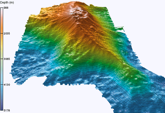
English: 3-D image of Loihi seamount after the collapse of the peak, obtained from R/V Ka'imikai-o-Kanaloa SeaBeam bathymetry taken during the LONO cruises. |
| Datum | |
| Quelle |
(Originaltext: National Science Foundation / National Oceanic and Atmospheric Administration / The Hawaii Undersea Research Laboratory (HURL) http://www.soest.hawaii.edu/HURL/images/loihi_3d.gif http://www.soest.hawaii.edu/HURL/hurl_loihi.html) |
| Urheber | John Smith and Brooks Bays |
| Genehmigung (Weiternutzung dieser Datei) |
PD See [1] |
Lizenz
Diese Datei ist gemeinfrei (public domain), weil sie Material enthält, das von einem Angestellten der National Oceanic and Atmospheric Administration im Verlaufe seiner offiziellen Arbeit erstellt wurde.
|
Ursprüngliches Datei-Logbuch
Übertragen aus en.wikipedia nach Commons durch Shizhao mithilfe des CommonsHelper.
Die ursprüngliche Dateibeschreibungsseite war hier. Alle folgenden Benutzernamen beziehen sich auf en.wikipedia.
- 2009-03-03 00:47 Resident Mario 529×364× (85757 bytes) {{Information |Description = What can you see/hear? |Source = [http://upload.wikimedia.org/wikipedia/de/4/49/Loihi_3d.gif Dutch wiki] |Date = Unstated |Author = US Gov Agencies |Permission = PD |other_versions = }}
Dateiversionen
Klicke auf einen Zeitpunkt, um diese Version zu laden.
| Version vom | Vorschaubild | Maße | Benutzer | Kommentar | |
|---|---|---|---|---|---|
| aktuell | 01:30, 26. Okt. 2009 | | 529 × 364 (84 KB) | wikimediacommons>File Upload Bot (Magnus Manske) | {{BotMoveToCommons|en.wikipedia|year={{subst:CURRENTYEAR}}|month={{subst:CURRENTMONTHNAME}}|day={{subst:CURRENTDAY}}}} {{Information |Description={{en|"3-D image of Loihi seamount after the collapse of the peak, obtained from [http://oceanexplorer.noaa.g |
Dateiverwendung
Die folgende Seite verwendet diese Datei: